METAR Decoder
Decode METAR and TAF reports in plain English. Search by ICAO code or paste a raw METAR — the tool walks you through wind, visibility, clouds, temperature, altimeter, and the active PIREPs and SIGMETs near the station.
Enter an airport ICAO code or paste a raw METAR string above to begin.
Try , , , ,
Understanding METARs
A METAR is a standardized weather report for pilots and aviation professionals. It is designed in a way which cannot be read by an average person without knowing the meaning of the weather codes. Although Student Pilots should know how to read the code, it can be confusing at first. Even experienced Pilots face difficulty understanding a few of the weather codes. This is where a METAR decoder comes into place.
A METAR Decoder simplifies the weather report and translates it into a format which can be read by anyone who can read English.
A METAR is a routine weather report which is updated every hour. It makes the Pilots and aviation professionals aware of the current weather situation.
It provides the following information:
- Wind speed and direction
- Visibility
- Cloud cover
- Temperature and dew point
- Atmospheric pressure
- Weather phenomena like rain, fog, or storms
METAR is essential for every Pilot for safe operations. Pilots look at METAR to analyse the weather situation and decide if it is safe to fly within their capabilities.
Reading METARs manually takes time and practice. Practicing can help you understand the report in one go. A METAR decoder tool helps you:
Translate instantly
Instantly translate coded METAR reports into plain English.
Save time
Save time during flight planning which is important for scheduled flights.
Avoid mistakes
Avoid mistakes in interpreting weather conditions as it can be a safety hazard.
Learn how it works
Learn how METARs work by comparing raw and decoded data. Our tool works great for learning purpose.
Whether you're a student pilot, aviation enthusiast, or preparing for exams, using a decoder speeds up your learning.
A METAR decoder is useful for:
- Student pilots preparing for exams or simply hesitating to ask their instructor on how to read a METAR report.
- Commercial pilot trainees who still haven't seen a lot of the weather codes.
- Aviation enthusiasts may use it just for fun. It is interesting to read METAR report.
- Flight dispatchers for preparing the flight plan or simply for learning purpose.
- Anyone interested in weather data. Yeah because it is just interesting to know every in and out of the weather rather than just knowing about the temperature.
If you're preparing for aviation exams, practicing with decoded METARs can make a big difference.
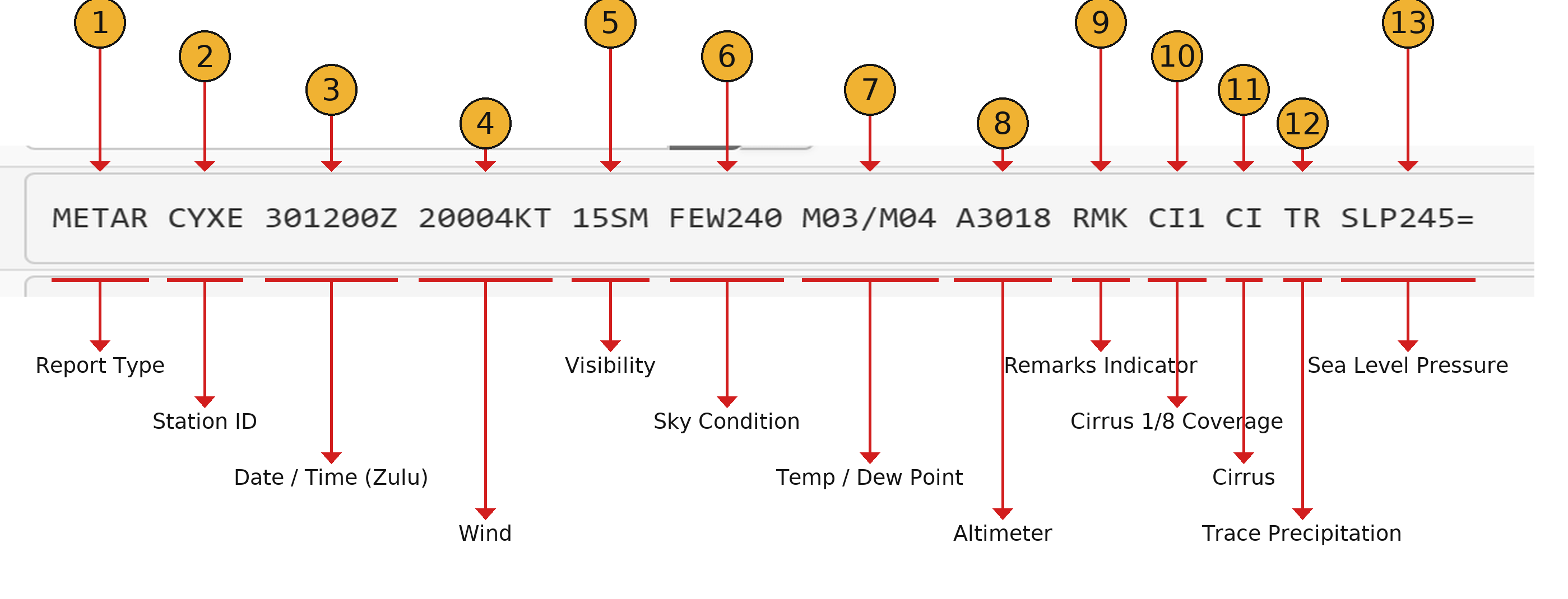
METAR CYXE 301200Z 20004KT 15SM FEW240 M03/M04 A3018 RMK CI1 CI TR SLP245=Report Type
The first word is simply the report type. It is written as a report page may contain other information such as TAF, NOTAMs, Pireps etc. To not confuse what type of report it is, the first word contains the report type which in this case is METAR.
Station ID
The second code in the METAR report is the Station ID. It contains the ID of the airport the report is for. In this case the station ID is CYXE which stands for Saskatoon Airport located in Canada. Another example of a station ID is VIDP which is for the International airport of Delhi.
Date / Time
The third code in the METAR report is the date and time in Zulu. The report is not provided in a local time but a standard time which is the zulu time. Don't forget to convert the time to your local time to make sure it is for the current time. The date and time are in the format DDHHMMZ. You can understand from the code, DD is for the day of the month, HH is for the hour of the day, MM is for the minute of the hour and Z stands for Zulu time.
Wind Direction and Speed
Next in a METAR report is the direction of the wind which in this case is 200 degrees and then is the speed of the wind which is 04 Knots in the case above.
Visibility
Next is the visibility. It is in different unit for every country. In this case is 15SM which stands for 15 Statute miles.
Sky Condition
Here comes an important part. The clouds! This part denotes the lowest ceiling of the clouds.
Temperature / Dew Point
Next is an important term for countries which are either very cold or very hot. The plane's performance is determined using this. The format is Temp/Dewpoint. If there an M before the numbers, it stands for Minus. In this case the temperature is negative 3 degree celsius and dewpoint is negative 4 degree celsius. Very close for the formation of fog!
Altimeter
Next in the report is altimeter. The unit is different in every country. Make sure to follow the standard unit of your country.
RMK
As the spelling suggests, it is short for Remarks.
The above data is enough for most of the METAR data but hey you can always use our METAR decoder to decode a METAR code you can't understand. Even experienced pilots use METAR decoder as a report may sometimes contain information which is rarely seen.
Three METARs decoded line-by-line
Each example below is parsed at build time so the decoded content is part of the page itself — no JavaScript required to read it.
Example 1 — Calm VFR day
KJFK
A textbook VFR report from John F. Kennedy International. Light westerly wind, ten-mile visibility, just a few clouds well above pattern altitude. This is the kind of weather that makes a great training day.
Plain English: Good flying weather (VFR): wind from the west at 15 kt gusting 22, visibility 10 miles, few clouds at 4,000 ft, 22°C / 72°F.
Raw report
KJFK 011856Z 28015G22KT 10SM FEW040 SCT250 22/12 A3001 RMK AO2 SLP164
Tokens
What each token means
- KJFK
- — Station KJFK
- 011856Z
- — Day 1, 18:56 Zulu (UTC)
- 28015G22KT
- — Wind from 280° (W) at 15 kt gusting 22 kt
- 10SM
- — Visibility 10 statute miles
- FEW040
- — Few clouds at 4,000 ft
- SCT250
- — Scattered clouds at 25,000 ft
- 22/12
- — Temperature 22°C / 72°F, dewpoint 12°C / 54°F
- A3001
- — Altimeter 30.01 inHg (1016 hPa)
- RMK
- — Remarks follow
- AO2
- — Remark
- SLP164
- — Remark
Example 2 — Marginal VFR with rain showers
EGLL
Heathrow on a wet morning. The visibility is still acceptable but the broken layer at 1,500 ft drops the field into MVFR — VFR pilots need to take the ceiling seriously and instrument-rated crews start to think about an alternate.
Plain English: Marginal VFR conditions: wind from the west-southwest at 18 kt, visibility 6000 m, light rain, scattered clouds at 800 ft, 9°C / 48°F.
Raw report
EGLL 011820Z 24018KT 6000 -RA SCT008 BKN015 09/08 Q1009 NOSIG
Tokens
What each token means
- EGLL
- — Station EGLL
- 011820Z
- — Day 1, 18:20 Zulu (UTC)
- 24018KT
- — Wind from 240° (WSW) at 18 kt
- 6000
- — Visibility 6000 metres
- -RA
- — Light rain
- SCT008
- — Scattered clouds at 800 ft
- BKN015
- — Broken clouds at 1,500 ft
- 09/08
- — Temperature 9°C / 48°F, dewpoint 8°C / 46°F
- Q1009
- — Altimeter 1009 hPa (29.80 inHg)
- NOSIG
- — No significant change
Example 3 — Low IFR with mist and a near-surface ceiling
VIDP
A typical low-visibility morning at Indira Gandhi International. Visibility under 1,500 m and a broken deck at 200 ft put the field firmly into LIFR. Low-vis procedures kick in, and only CAT II/III-capable crews and aircraft will be flying approaches here.
Plain English: Low IFR — significantly reduced visibility or ceiling: variable wind at 2 kt, visibility 1200 m, mist, broken clouds at 200 ft, 14°C / 57°F.
Raw report
VIDP 011230Z VRB02KT 1200 BR BKN002 OVC020 14/13 Q1018 NOSIG
Tokens
What each token means
- VIDP
- — Station VIDP
- 011230Z
- — Day 1, 12:30 Zulu (UTC)
- VRB02KT
- — Variable wind at 2 kt
- 1200
- — Visibility 1200 metres
- BR
- — Mist
- BKN002
- — Broken clouds at 200 ft
- OVC020
- — Overcast clouds at 2,000 ft
- 14/13
- — Temperature 14°C / 57°F, dewpoint 13°C / 55°F
- Q1018
- — Altimeter 1018 hPa (30.06 inHg)
- NOSIG
- — No significant change
Reading the badge
The coloured badge in every decoded report classifies the airfield by its visibility and ceiling. The thresholds come straight from the US National Weather Service standard.
Visual flight rules — visibility > 5 SM and ceiling above 3,000 ft
Marginal VFR — visibility 3–5 SM or ceiling 1,000–3,000 ft
Instrument flight rules — visibility 1–3 SM or ceiling 500–1,000 ft
Low IFR — visibility under 1 SM or ceiling below 500 ft
Glossary
Core aviation-weather terms that appear on this page and across pre-flight briefings.
METAR
A coded current-weather report issued by an airport, normally every 30 or 60 minutes. The raw form is what controllers and pilots use over the radio.
TAF
Terminal Aerodrome Forecast — a forecast of expected conditions at an airport, typically valid for 24 or 30 hours.
PIREP
Pilot Report — conditions actually encountered in flight (turbulence, icing, cloud tops). Filed by crews and shared with other pilots and ATC.
SIGMET
Significant Meteorological Information — a warning of weather hazardous to aircraft (severe turbulence, icing, volcanic ash, thunderstorms).
AIRMET
Airmen’s Meteorological Information — advisory for less severe but still important conditions (moderate turbulence, IFR ceilings, mountain obscuration).
VFR
Visual Flight Rules. Conditions in which a pilot can fly by visual reference: visibility greater than 5 SM and ceiling above 3000 ft AGL.
MVFR
Marginal VFR. Visibility 3–5 SM or ceiling 1000–3000 ft. Legal for VFR flight but starts to limit options.
IFR
Instrument Flight Rules. Visibility 1–3 SM or ceiling 500–1000 ft. Requires instrument-rated pilot and instrument procedures.
LIFR
Low IFR. Visibility under 1 SM or ceiling below 500 ft. Approach minimums and equipment matter; many airports become unusable.
Altimeter
The local barometric pressure setting pilots dial into the altimeter so it reads correct height above sea level. Reported in inches of mercury (A) or hectopascals (Q).
Dewpoint
The temperature at which air would saturate. The closer dewpoint is to temperature, the higher the chance of fog or low cloud.
Visibility
The horizontal distance at which prominent objects can be seen and identified. Reported in statute miles (US) or metres (international).
Ceiling
The height above ground of the lowest broken or overcast cloud layer. Drives the flight category alongside visibility.
Knots
Nautical miles per hour. 1 kt ≈ 1.151 mph ≈ 1.852 km/h. The standard unit for wind speed in aviation.
Zulu (UTC)
Coordinated Universal Time, written with a trailing "Z". All METAR/TAF times are in UTC so reports compare cleanly across time zones.
RMK
Remarks. Free-form supplementary information appended to a METAR — sea-level pressure, sensor status, peak winds, and so on.
AO2
Automated station with a precipitation discriminator. AO1 means automated without one. Found in the remarks of US METARs.
SLP
Sea-Level Pressure, reported to 0.1 hPa in the remarks. SLP182 means 1018.2 hPa.
Flight Level
Altitude in hundreds of feet referenced to the standard pressure datum (1013.25 hPa). FL310 = roughly 31,000 ft.